Tuesday, February 12, 2013

SAN AUGUSTINE COUNTY

San Augustine County: For a number of years now I have traveled northeast from Houston up US Highway 59 to Lufkin Texas, then headed due east on highway 103 across lake Sam Rayburn to San Augustine County and the Angelina National Forest. To me this is really beautiful country with rolling hills and majestic tall forest of pine, oak and hickory accented by gorgeous dog wood trees in the spring. In the later part of the year towards fall and hunting season the forest is a blaze with color from sweet gum, oak and more. I would compare the color here to any stand of maple trees up north, and say we win hands down! Seriously, it is just beautiful! Take a trip around Lake Rayburn from Jasper to Lufkin to San Augustine and down highways 147, 103, 21, 96, 63 or 705. The traffic is light as the population for the county is only 8,865 from the 2010 census. The county seat is the city of San Augustine founded in 1837 and is one of the earliest cities in Texas. Be sure and stop on the old city square where the county court house and jail is located. There is alot of history waiting for ya there!


San Augustin, Texas

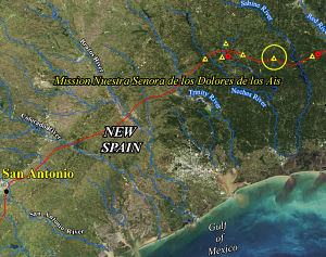
 It is also an interesting fact that as early as 1691 and for more than three and a half centuries people have been traveling through this part of Texas along what's now known as the Old San Antonio road or the Old Spanish Trail or El Camino Real. This road travels roughly from Natchitoches LA down to San Antonio TX, going through San Augustine County mostly east to west. The early Spanish explorers and priests built missions along this road to attract and convert Indians into settled Christian citizens. One such mission was the Mission Dolores, built in the early 1720's, at the present day town site of San Augustine, Texas off highway 96 & 21 near highway 147. The mission was not abandoned until 1773 so this mission was an active settlement for some 50 years, were the Spanish priests, soldiers and settlers interacted for the most part, peacefully with the local Indians. There are published accounts of many wagon trains and traders traveling through this area and along the Old San Antonio road. The Spanish often hauled silver and gold bars, coins and jewelry along this route to bargain for supplies needed on the long and dangerous trip to San Antonio. Not all of the Indians or early settlers  were friendly along the route and there were many stories about travelers that never made it all the way to their intended destinations. What happened to them and the gold or silver or jewelry will probably never be known for sure but that is certainly the stuff legends of buried treasure are made of.  So pull out that metal detector and dust off the GPS and do some treasure hunting anywhere from San Augustine to Nacogdoches to Bryan and on down toward San Antonio. The Old Spanish Trail is still marked and parts of the road are the exact same trail used many years ago. Of course now of days, you'll have to check with land owners first and please be aware that State and National Parks prohibit removal of artifacts or minerals found on the grounds. But Hey, other than that, knock yourself out and make yourself rich when you find that long lost cache of gold. Wow! would that be exciting or what! Now where in the world did I put that metal detector I use to have somewhere? lol

Spanish 8 Escudos Gold Royal Doubloon Coin Replica
Spanish Gold Coins

photograph
The Old Spanish Trail & Mission Delores

Wednesday, August 29, 2012

MATAGORDA COUNTY

Matagorda County is southwest of Houston off Hwy 59 and Hwy 60 out of Wharton Texas, south  headed down to Bay City and the beautiful Texas gulf coast. Bay City is the county seat of Matagorda County, being the largest city of the county. Matagorda county has a population just over 36,000 and covers 1,114 square miles of land with nearly 500 square miles of water. Folks, the beach and shore line along Matagorda bay are a real treasure. My favorite trip is to take highway 60 south out of Bay City into the city of Matagorda and then take FM 2031 all the way down to the gulf. You will cross an old draw bridge across the inter coastal canal and finally come to a nice park and pavilion located on the beach just east of where the Colorado river empties into the gulf. There is a huge walk out rock pier for fishing and your sure to catch something most every time you throw out. The bird watching is also a huge recreation here, so pack some binoculars for a good view. If you make the boat trip on the other side of the Colorado river to the Matagorda island it is something else to see. Beautiful and pristine beaches with no crowds. There are plenty of RV spaces, rental houses and cabins in this area and most are very reasonably priced. The full Stringer Realty is a good place to start looking for accommodations and there are a lot of fishing guides listed on line. If you like the beach but hate the crowds then this is certainly your spot.


AERIAL VIEW MATAGORDA PARK
 
DRAW BRIDGE
 
COVERED AREA ON BEACH
 

Sunday, August 26, 2012

Wharton County Texas

Southwest of Houston along highway 59 as you cross the San Bernard River you will drive through Wharton county. The land is mostly level and cleared with scattered clumps of trees here and there. You will see a lot of large old oak trees from long ago plantation days and man made irrigation canals from the rice farms. Wharton county was founded in 1846 and named after the Wharton brothers William and John Wharton. The county seat is the city of Wharton Texas where the Wharton County Courthouse stands. It's a beautiful building with interesting shops around the old court house square.

Wharton County Courthouse

I stopped in Wharton on my way down to El Campo which is just a short distance on down Hwy 59.  These two cities make up the majority of population in Wharton County which was slightly over 41,000 in the 2010 census. The San Bernard river forms the northwest border of Wharton county and the Colorado river runs roughly from northwest to southeast dividing the county in half. If you like duck hunting and fishing this is a great place to start. Wharton is also right on the way to Bay City and Matagorda Bay. Now that's some of the best bay fishing on the Texas gulf coast. There are lots of fishing guides available and plenty of reasonable accommodations along the gulf area.

Friday, April 20, 2012

Plantations of long ago - Fort Bend County

As I drove southwest from Houston and Harris county out highway 59 to Fort Bend County, I found it hard to imagine, what this suburban sprawl we call Sugar Land Texas, must have looked like when it was a plantation of Colonel E. H. Cunningham in the early 1800's. The plantation raised sugarcane and corn, covered thousands of acres and I'm sure was quite a sight to see. Driving on to Richmond Texas, which is the county seat of Fort Bend county, you do see bits and pieces of the old oak trees and pecan trees and farm land that once dominated the county. But then came the Civil War of 1861 and the good Colonel lead his Mustang Grays with Hood's 4th Texas Brigade to fight with Robert E Lee. At the battle of Gaines Hill, when they turned McClellan's right flank, General Lee said it was one of the most brilliant charges of the war. Now that's high praise from high places, I think, and interesting history.

The city of Sugar Land Texas is today the largest city in Fort Bend county and growing by leaps and bounds as is Missouri City Texas and Richmond Texas and Rosenberg Texas. In fact Fort Bend county is one of the fastest growing counties in the whole United States and not just in Texas. Fort Bend has a population of 585,375 as shown in the 2010 census, which was a 65% increase over the 2000 census. That is excellent growth and this county has had this kind of growth since the early 1980s. In fact, as I looked at the past census, the population increase for Fort Bend county has been above 90% growth rate on average from 1980 to 2000. Land prices around this county have also followed suit. As a real estate broker I can't help but wonder what Colonel Cunningham would think of the present day high land prices in Sugar Land Texas, compared to the low plantation land prices in his day and time. Fort Bend county started and was named after a simple blockhouse built in a bend on the Brazos river by colonists of Stephen F Austin's colony. Fort Bend county was founded in 1837 and covers 886 square miles, mostly level land with scattered trees. The old oak trees around the county courthouse in Richmond Texas are beautiful to see and certainly make you think of the long gone plantation days. There is plenty to see and do in Richmond Texas and the museum across the street from the old courthouse is worth a stop just to stroll the grounds and feel the sense of days gone by. It made me think of Scarlet O'Hara and the movie Gone with the Wind.

                                                       Fort Bend County Courthouse


In the southeast corner of Fort Bend county along FM 762 you will find the Brazos Bend State Park. It is a beautiful park of about 5000 acres between Needville Texas and Rosharon Texas. This area was part of the original land grant to Stephen F Austin and the present park area was included in a grant to Abner Harris and a partner named William Barrett. Archaeological materials show that prehistoric people visited this area and the Karankawa Indians roamed between the mouth of the Brazos river and Galveston bay to the east. There are beautiful hiking, biking and equestrian trails as well as camping, fishing and spots for a picnic. The bike trails alone cover about 35 miles of pristine wilderness with a lot of deer, birds and alligators to see as well as some of the most beautiful wetlands and trees you can ever hope to see. So take a day and see the park and visit the center as well as the observatory. The views are spectacular.


For more information on the Brazos Bend Park check out the Texas Parks and Wildlife website below and click on my photos page for some of the pictures posted.

Reference Links to Fort Bend County


Saturday, April 14, 2012

Brazos County and Burleson County Texas

If you are headed Northwest out of Harris county to catch a glimpse of the beautiful Texas wild flowers this Spring be sure to include Burleson County on your list of Texas counties to see. From Brenham Texas you will head north to Somerville along highway 36 to go through Burleson county. Lake Somerville is on the southern line of Burleson county and it is a great place to visit for fishing and camping. It has a lot of camp sites with tables and other necessary conveniences. I have enjoyed many weekends at this lake and the camp grounds. I certainly do recommend it to you if you like to get outdoors to have fun in the sun, wet a hook or just take a boat ride. Burleson county is very wooded for the most part with mostly sandy loom soil and a fairly level landscape with elevations around 200 feet to 475 feet. Burleson County was founded in 1846 and the county seat is in Caldwell Texas.

 Caldwell Texas is north of Somerville where highway 36 and highway 21 cross each other. Highway 21 is also known as the Old San Antonio Road which was traveled as early as 1713 to 1718. Early settlers in Burleson county faced a lot of dangers along the Old San Antonio road including Indian raids, but face them they did and were part of Stephen F Austin's first colony in the 1820's. As I drive along this old quite country road I can't help but think about the many faces that have traveled this way before. That's a lot of history your flying by, so why not stop a while and consider the beauty all around you. There is after all 678 square miles of total area in the county with plenty of room for you.

 By the 1840's the Indian threat was small and the 1850 census showed no Indians in the county. The antebellum Texas of the early 1800's was noted in 1847 with 866 whites and 330 slaves in the county. Then came the civil war in 1861 and reconstruction to follow, with very violent and chaotic times. Outlaws and brigands or veterans unwilling to give up the fight roamed the country along Yegua creek rustling cattle and stealing horses and whatever they thought they could get away with. Even the notorious Sam Bass and his gang where said to have lived in the area for a time. However, from about 1870 with the Chisholm trail drives following the Brazos river through the county there was steady growth and improvements. The cotton planters received improvements in transportation when they began hauling their cotton to the Houston and Texas Central railway line in near by adjoining Brazos County. Then in the early 1880's the Gulf, Santa Fe and Colorado railway extended lines to Caldwell. And the rest as they say is history. the current population of 17,187 is still mostly rural and farm land and yes they still grow cotton, especially along the Brazos river.

Now on the other side of the Brazos river from Burleson county  Brazos County founded in 1841. The county seat of Brazos county is Bryan Texas and the city is part of the Bryan College Station metropolitan area. The growth in this county is very impressive and investments in land here reflect that growth. When I looked at the census records from 1850 on there is positive growth in this county every year except one negative span in 1930. From 1940 to 2010 the census shows 25% to 63% growth year after year. The current population is over 194,000 and continuing to grow. There is 590 square miles of area in the county, so it is smaller than it's neighbor Burleson county, but the city of College Station with the Texas A & M campus adds a lot of growth to the community. As a real estate broker I see a lot of investment potential in land growth for Brazos county with plenty of wide open spaces if you need to spread out a little. The drive out highway 21 headed north east along the old San Antonio road is a good place to start.

The old San Antonio road or old Spanish Trail, as some like to call it, runs along the north line of Brazos county. There are many old tails about lost gold shipments, never found from this stretch of highway. One such story is about a mule train carrying a load of gold and silver to San Antonio being attacked and the gold was buried by a petrified tree near Bryan. They say it was never recovered. I can certainly imagine how dangerous it was to travel along this road long ago in the early 1800's with Indians and outlaws waiting around every hill or crossing.  Other legends of the Brazos river bottom are fun to explore and will leave you wondering  if they are really true or not. Of course the ghost stories from the boggy bottom land of the Brazos valley will also keep you looking over your shoulder as well.  The land is picturesque with a slight roll to mostly flat and lots of wild flowers and trees especially along the creeks and gullies and low areas draining into the Brazos river. The hill top views are spectacular and seem to call out for a picnic spread. This is nice country folks and well worth the trip to see it. Friendly people will also make you want to stay a while and just say Howdy

Reference link     http://en.wikipedia.org/

Thursday, April 12, 2012

North and North West Where Trees Grow Tall

Before you leave Harris county headed Northwest on Hwy 249, you will go through my old home town of Tomball Texas. It is a mighty fine place to stop and see some very friendly people and spend some time especially in the old downtown part that has now become a collectors dream of fine antique shops. When you cross the spring creek bridge you have arrived in Montgomery County, which was founded in 1837 and named for the town of Montgomery Texas. Conroe Texas is the county seat of Montgomery county. Montgomery has been recognized as the official birthplace of the Texas Flag. Now I don't know about everybody else, but that flag, the Texas Flag, is very near and dear to this old boy's heart. So my hats off to Montgomery County for that fact alone. Dr. Charles B. Stewart is credited with creating the very inspiring lone star Flag of Texas. But I am also a real estate broker and this next little bit of information has really made me sit up and take notice of the land in this county. From the 2010 census Montgomery county has a whopping 55% growth rate making it the 24th fastest growing county in the whole United States. The population in 2010 was 455,746 and they are still growing and counting. They do have a lot of land and beautiful trees to grow on with 1,077 total square miles of water and land area. In fact if you like census data and numbers, Montgomery county is the place to look for extended population growth. Look at these numbers. In 1970 they had 84.4% growth rate, 1980 they had 159%, In 1990 41% and 2000 was 61%. Now that is impressive growth for any area and real sustained growth. I also love the beautiful trees in the Sam Houston National Forest which is located mostly north of lake conroe and north of the town of Montgomery. Walking trails and bike trails and camping are all there and just a few minutes from newly built restaurants and shopping. Oh, and did I mention beautiful lake Conroe? Boating, fishing, skiing, sailing and nice accommodations everywhere. I mean, come on folks, what's not to like about this place. It really does have it all and you should see some of the golf courses in this county. Bentwater and Woodlands TPC to mention a couple, are first rate courses and absolutely beautiful to play or see.

Adjacent to Montgomery County is Grimes County to the west. Grimes county was founded in 1846 and the county seat is Anderson Texas. Grimes county was named after Jesse Grimes who was an early settler and a signer of the Texas Declaration of Independence. Grimes county is somewhat smaller than its neighbor Montgomery county, with only about 800 square miles of area but not the smallest county by far. As I traveled through Grimes county to Anderson Texas, I was impressed with the rolling country side and the beautiful wild flowers. I have heard this county called the land of milk and honey and I could certainly see why. It is drop dead gorgeous, from a real estate man's point of view. I mean everywhere you look is green and lush, with rolling hills and beautiful trees and did I mention wild flowers. Oh yes, lots and lots of those. My good friend and fellow blogger, Larry Hugonin, went with me on this trip so we could be sure and get plenty of photos for our faithful readers who love the Texas blue bonnets and wild flower. Now if I can just figure out how to get them downloaded to this blog before the publish time. I hope everyone will enjoy our efforts. Thank you Larry, for all the help and all of your good eye shots. The Grimes county courthouse in Anderson Texas is worth the drive in and of itself, so I hope you can visit soon and enjoy the drive as we did.

Reference link     http://en.wikipedia.org/

Saturday, April 7, 2012

Washington County

Since I have been to Washington County and the county seat in Brenham Texas many times over my life, I felt I should include it in my blog as soon as possible. What better time than now, at Easter weekend when a lot of you will be driving through there just to catch even a short look at the blue bonnets. It is a pleasure to see the land and wild flowers and smell the fresh green lush fields that make up this beautiful panorama of Texas landscape. From the Brazos river and Chappel Hill then on up to the Washington on the Brazos Park and Independence and over to Burton there is nothing quite like it. Wow! That's what I say, It will simply wow you. If you can't get out to see this amazing display of wild flowers I hope in some small way my photo page will convey what it's like to drive through this county.

Washington county was founded in 1836 and of course is know for the convention of 1836 where the Texas Declaration of Independence was signed. Do yourself a big favor and take at least a whole day to visit the Washington on the Brazos State Park. It is very interesting and there is a lot to see. The Texas  museum and the special movies and programs are really great. Then there is the restored building where the actual declaration of Independence was signed and also on the grounds is a restored farm doing the every day chores of early Texas settlers. This part is a must see, complete with the house, barns, oxen, chickens, gardens, cattle and everything you would imagine like tools and old farm implements. The reenactment is very interesting to see and the actors are very knowledgeable of the time period. Then if that's not enough, you can stroll the grounds down to the Brazos river and enjoy the picnic grounds surrounded by huge old pecan trees and oak trees, with plenty of benches and tables or just spread out a blanket on the ground. There is a location on the Brazos that points out the old river crossing where the ferry use to be. And the sign describes the panic of people trying to cross the river before Santa Anna and his troops could trap them on the wrong side of the river. I can just imagine how terrifying that could have been.

Washington county is not a large county in size but it does cover 621 square miles. It has had fairly steady growth since the 1980's at about 15% every ten years when the census is taken. The 2010 census was down a little and showed only a 11% increase with a population at 33,718. I mentioned that the county seat of Washington county was Brenham and I should have added that the Washington county courthouse was in Brenham. Blinn junior college is well know and respected in Brenham and I have known many good friends of mine that started out at Blinn college. Washington county and Brenham Texas are also home to that wonderful company we all know as Blue Bell Ice Cream. I myself would not miss an opportunity to take the Blue Bell factory tour as often as I could. Why just last summer I had the pleasure of taking the tour with my grand children and it was great! I always have a hard time making up my mind between homemade vanilla or chocolate. So I usually end up getting them both. Yum! Do yourself a favor and go this year. You will love it. And go have a picnic on the Brazos river at the park while your at it.

Reference link   http://en.wikipedia.org/